
Ierland


individuele reizen
Dingle - 8 dagen
Dingle Way, trektocht langs B&B's
zwaarte 
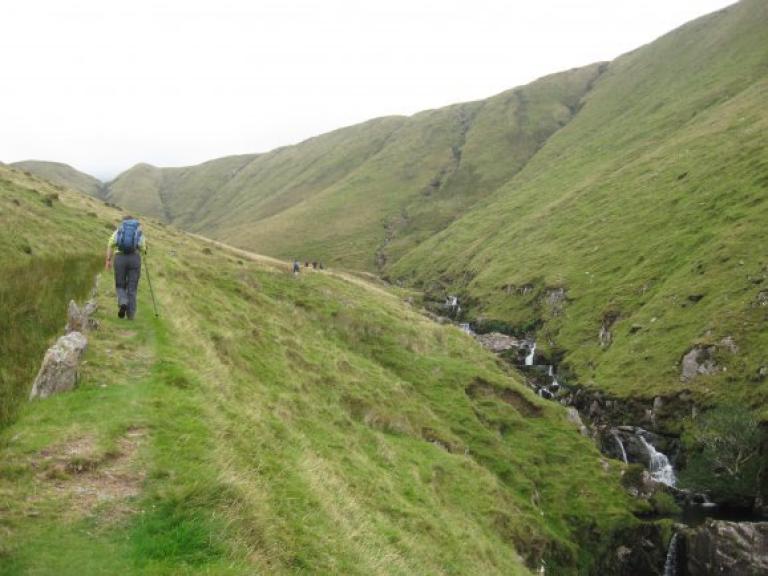
U wandelt over lange onverharde lanen met fuchsiahagen en een weelderige bermvegetatie. Het moorland, hoger in de heuvels, is in sommige tijden van het jaar knalgeel van de brem, in de vroege nazomer al gauw prikkelend paars door de bloeiende heide. De kust hoort tot de spectaculairste van de wereld. En het klimaat? Er groeien mediterrane planten en zelfs palmbomen.
In het echte Ierland kan ieder pubbezoek uitlopen op een spontane zang- en danspartij. Die sfeer vindt u op het Dingle Peninsula, de meest westelijke punt van Ierland. “The Dingle Way” voert u over groene landweggetjes langs bijenkorfvormige stenen hutten en andere archeologische monumenten.
Day 1 – Arrival to Camp Village
Travel to Camp via Tralee on scheduled bus service or by taxi. Camp is situated overlooking Tralee Bay to the north with the majestic Gearhane and Caherconree peaks to the east. It has been an historic crossing point of the Slieve Mish Mountains since the first settlers were here in 1700BC . Camp is a small settlement, with plenty of local colour and a short circular walk to limber up for the kilometers ahead!
Overnight accommodation in Camp village.
Day 2 – Camp to Anascaul via Inch Strand
Hike to the south on turf cutting roads, through the glorious bogland of Slieve Mish- the wilderness of the blanket bog is punctuated with conifer forest and the stacks of drying turf. Skirt Ardroe Hill, overlooking the magnificent 8km of sand dunes and beach at Inch, with views south to the Ring of Kerry and Ireland’s highest mountain range, before following the “Maum” (pass) down to Annascaul village.
Distance 18.5km. Ascents 460m. Approximate walking time 6 hours.
Optional extra hike over Brackaloon Hill, 5km (2 hours).
Overnight accommodation in Annascaul village.
Day 3 – Anascaul to Dingle
Follow Acres Hill to the staunch remains of 12th century Minard Castle, mostly destroyed by Cromwell’s army in 1650. Turn inland again on minor roads to the railway village of Lispole. All the way you are within scent of the seas of Dingle Bay and encircled by the Kerry Mountains. From Lispole, the Way follows mostly sheep farming country before climbing An Cnoc Maol Mor and descending the old green droving road into Dingle town.
Distance 23km. Ascents 560m. Approximate walking time 6-7 hours.
Overnight accommodation in Dingle town.
Day 4 – Dingle to Dunquin
Minor roads take you from Dingle to Ventry; beyond is some of the most spectacular scenery you could hope to find. Cross the magnificent Ventry harbour, weave through fuchsia hedges and climb an old track on the foothill of Mount Eagle past the early Christian beehive huts at Fahan. Behind are views south to the Ring of Kerry and Valentia Island. Ahead the route opens up to Slea Head and the Blasket Islands. This is the most westerly point in Europe, beyond is North America!
Distance 25km. Ascents 650m. Approximate walking time 7 hours.
Optional route over Mount Eagle, 7km, 365m and 3 hours
We include notes for this climb, only advisable in good weather conditions.
Overnight accommodation in Dunquin village.
Day 5 – Dunquin to Ballydavid
We recommend a visit to the Blasket Island Interpretative Centre before departing Dunquin, illustrating the harshness of life on the Blasket Islands until the last inhabitants resettled to the mainland in 1953. The route follows the Norse named Smerwick Harbour and a detour takes you to Dun an Oir, the Fort of Gold, where Italian and Spaniard soldiers were besieged by troops of Elizabeth 1 in 1580. Ballydavid is a thriving fishing harbour and a Gaelic speaking community.
Distance 16km. Ascents 180m. Approximate walking time 5 hours.
Optional route over Cruach Mharthain add 1 hour
Overnight accommodation in Boherboy near Ballydavid village or Feonanagh. (+3-5km from Ballydavid)
Day 6 – Ballydavid to Cloghane
You are in the cradle of early Christian civilization here, with as many as sixty notable sites of cultural and religious development from the 5th to 9th centuries. Today’s hike takes you up; up to the saddle of Mas an Tiompain (the Pass of the Drum) below Mount Brandon, Ireland’s second highest mountain at 950m. The scenery is superb – Tralee Bay, the Magharees against the hues of the Slieve Mish mountains. The descent to Cloghane is nothing short of thrilling on a clear day, and well-earned respite is available in the village!
Distance 22km. Ascents 750m. Approximate walking time 7-8 hours.
Overnight accommodation in Cloghane village.
Day 7 – Cloghane to Camp
Back at sea level, today’s walk follows the coast, all the way around the Castlegregory promontory if you desire, or across the neck of the spit via Lough Gill, home to Bewick swans and Natterjack toads. From Castlegregory village, mudflats and turf cuttings, quiet coastal paths give way to farmland and a climb back to Camp.
Distance 22km or 32km. Ascents 30m. Approximate walking time 6 or 8 hours.
Overnight accommodation in Camp village.
Day 8 – Departure from Camp
Scheduled bus services from Camp to Tralee (20 minutes) for onward connections.
zoeken in
filteropties
extraSmallDevice
smallDevice
mediumDevice
largeDevice